New Zealand Trip 2006
Introduction
In mid-2006, I decided that I wanted to use up some of my long-accrued vacation, and started planning a 5 week trip to New Zealand. I’d wanted to go to New Zealand for a couple of years, after having seen photos of the country from my friend Josh’s ’round the world trip.
Typically, for me, planning a trip involves booking transportation, getting a rough idea of what I want to do, and figuring things out when I get there, a tendency which annoys some of those close to me to no end. I didn’t want New Zealand to be any different, so I booked airfare and investigated my in-country transportation options pretty carefully. I finally settled on renting a campervan, so that I’d be able to set my own pace for exploring the country. That settled, I booked the only activity I really had to book in advance, a hut ticket for the Milford Track, which is reputed to be the “finest walk in the world.” That settled, I geared up for the trip, buying lots of photography and hiking gear, and prepared myself for my first vacation outside of North America.
Outward Bound
On November 15th, I boarded an Air New Zealand flight bound for New Zealand. It’s a long flight, so I’ll spare you the details, but after what seemed like an eternity (I don’t sleep very well on airplanes) I arrived in NZ, at 5am on the 17th. Losing a day threw me off a bit.
As I groggily made my way through customs, I noticed that New Zealand seems to care a great deal about “biosecurity”, aiming to preserve the local wildlife and native biology through preventing intrusive species from coming into the country. My hiking boots had to be declared, and were given a good looking at. I felt sorry for a forlorn looking cowboy in the X-ray line by himself, his saddle and tack up on the conveyor belt and boots off for inspection. He looked like he’d been there before and expected to be there for awhile.
After catching a taxi to the Auckland Hyatt, I hoped to do a super-really-early check-in, but had to wait until past 10am for my room to free up. I was glad I’d booked a few nights there, as I was totally exhausted, and, as is par for the course for me on flights, I’d come down with a cold. However, having five hours to kill, I wandered around downtown Auckland taking pictures, which was fun, although not quite as much fun as going to sleep would have been.
Auckland is an easy city to navigate on foot, and being a pedestrian for a couple of days was a good way for me to get used to cars driving in the left-hand lane from a perspective other than that of behind a steering wheel. It’s also a tidy city, with people who speak in a strongly British-influenced accent, with a strong showing of Asians reminding me that I was on the Pacific Rim. In those ways, it reminded me of Vancouver. In others, the feel of the city is much like San Francisco, with quirky little shops, big company headquarters, a smattering of tech startups, and a wide selection of good places to eat. It’s also a city on the ocean, which helps with the San Francisco vibe, and so it didn’t take me long to start feeling comfortable.
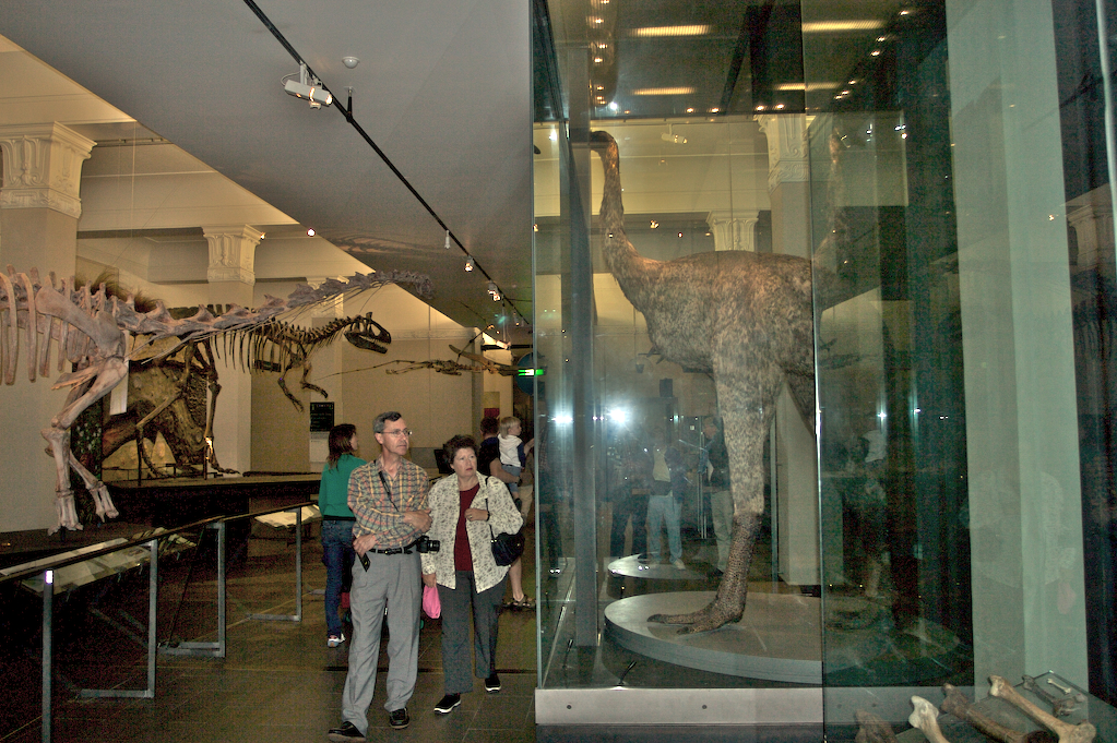
After catching up on my sleep that night, I set out to explore a bit. First, I caught a bus to the Parnell area and walked over to the Auckland Museum. The Museum’s collection runs the gamut from natural history, to artworks and furniture, to Maori artifacts and WW2 warplanes. The most interesting thing, for me, was the collection of stuffed native birds, including reproductions and skeletons of Moa. Moa were giant flightless birds native to New Zealand that grew to up to 13 feet in height, and standing next to one made me appreciate how terrifying they must’ve been for the Maori who hunted them.
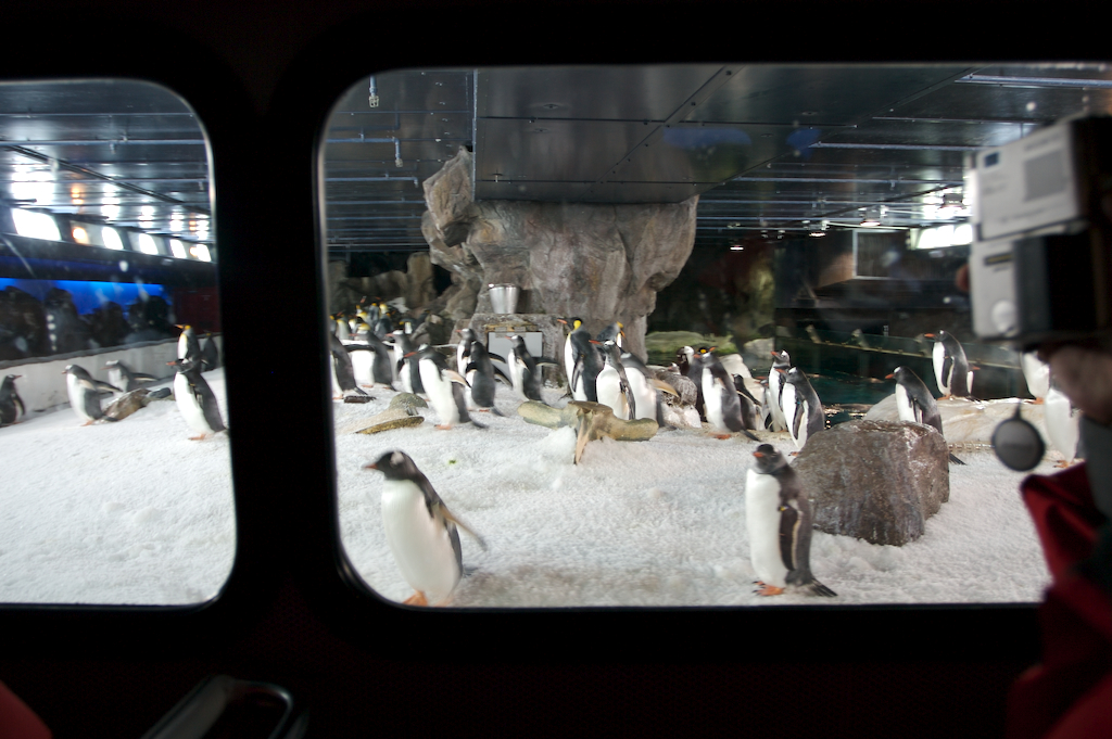
Another highlight of Auckland was Kelly Tarlton’s Antarctic Encounter and Underwater World. As the name would suggest, it’s a cross between an aquarium and an antarctic exhibit. This was the only place in NZ where I saw penguins, and was by far the best aquarium I went to, with the 110m long underwater tunnel and the giant squid on display being real highlights. Here I also learned that an adult octopi can fit through a hole the size of a dime. Apparently, Kelly Tarlton’s used to have a problem wherein crayfish (giant NZ lobsters) would be found eaten when they opened the aquarium in the mornings. It turns out that an octopus had been squeezing out a tiny hole at the top of its tank every night, crawling across the floor to the crayfish tank, eating a crayfish, and crawling back before morning. Neat.
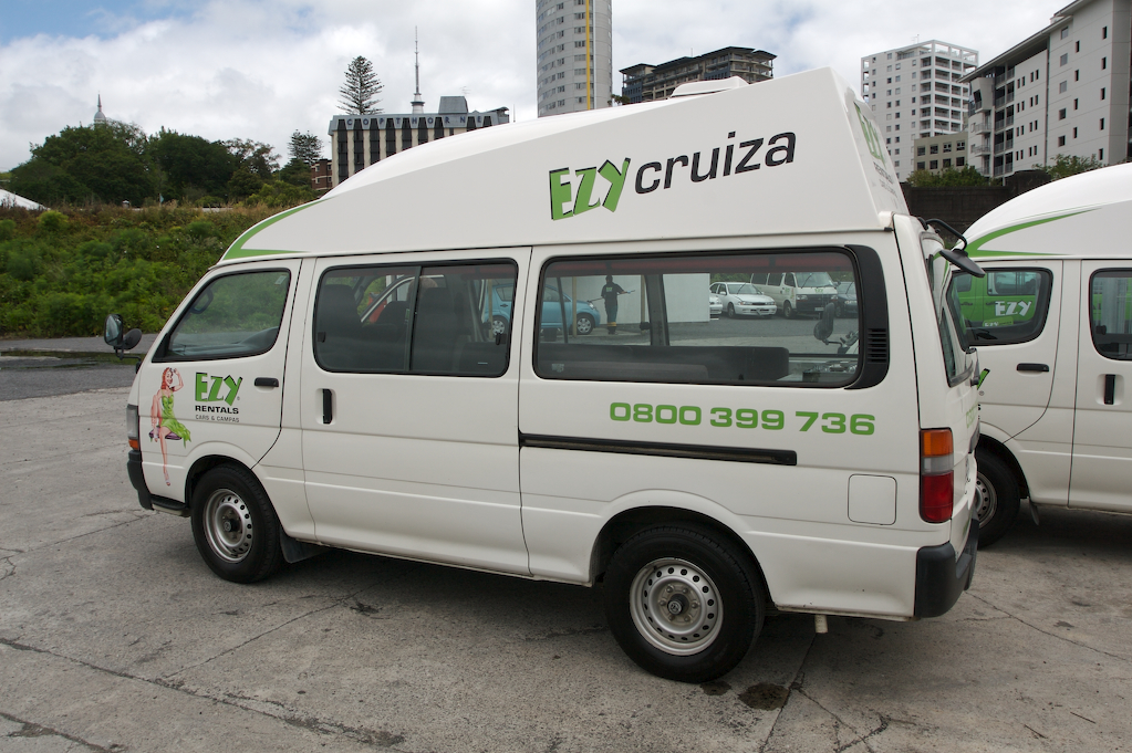
Also in Auckland, I picked up my transportation: a Toyota Hiace campervan from Ezy rentals. The Hiace is a popular, cheap, and incredibly wimpy van, which in my case had been professionally converted to have seats in the back that convert to a bed, plus a stove, sink, refrigerator, and microwave. Mine was also fitted with a giant fiberglass top, which served both to increase headroom and, as I discovered later, act as a huge sail in the wind, whipping me all over the road. Fun.
Nevertheless, I quickly got up to speed on driving. As I’d given myself a few days as a pedestrian to observe traffic from the sidelines, it wasn’t that hard to adjust to driving on the left hand side of the road. It helps that Kiwis (as New Zealanders call themselves) are incredibly polite, even while driving, and the speed limits are pretty low compared to the US. I quickly grew to appreciate the consistent use of roundabouts, which make traffic move much faster than stop signs would allow.
From Auckland to Rotorua
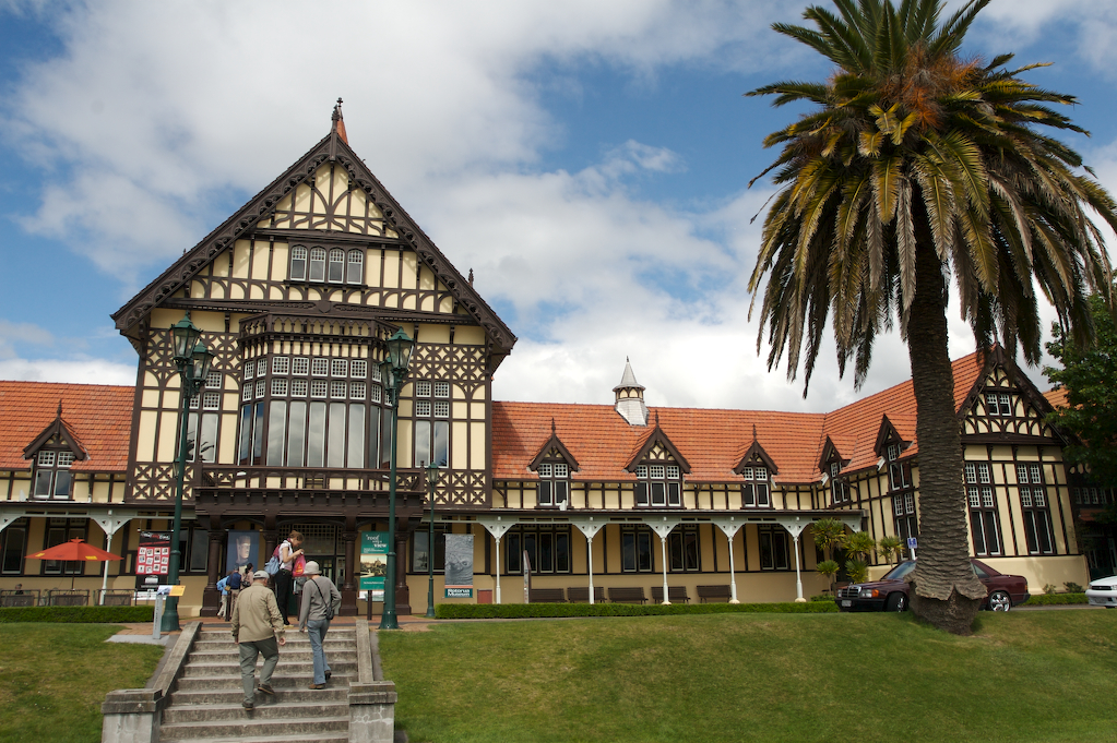
On the 20th of November I set out from Auckland to Rotorua. The drive was most uneventful, taking me through lots of green grassy areas, and past plenty of sheep. After wandering around the town getting my bearings, I visited a fancy old spa built in the 18th century. There I learned that long ago they used radium-infused water to “treat” people. Aahhhh! Afterwards, I ate dinner in town and drove to my first campervan site for the night.
Campervan parks (also called holiday parks) are basically the equivalent of RV parks in the US, offering laundry and shower facilities, along with electric hookups for campervans. The site in Rotorua was pretty nice, set along side a small stream, with well-maintained facilities and even wireless Internet access (for a fee).
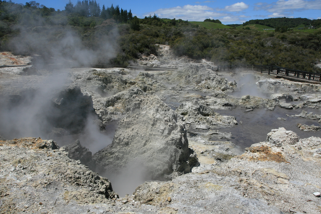
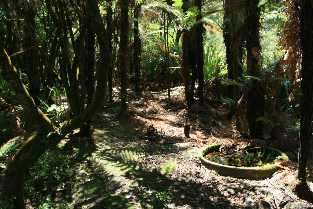
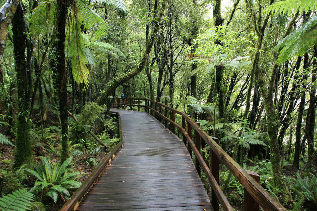
The next day, after some drama involving not being able to open the safe in my campervan to retrieve my camera gear, I headed out to see some of the sights. Rotorua is famous for its thermal formations, so I went to the nearest one, known as Hell’s Gate. George Bernard Shaw once said of this place, “I wish I had never seen the place, it reminds me too vividly of the fate theologians have promised me.” Indeed, George’s description is apt, and the Maori tribe which owns the site has a taken the theme and run with it, giving names to the various formations such as Devil’s Cauldron, Sodom and Gomorrah, Devil’s Bath, and Map of Australia (Kiwis have a friendly rivalry with their Western neighbors). While there, I also had my first chance to look at New Zealand tree ferns up close. These ferns grow to be quite large (20′ tall or more) and are quite sturdy. They also look like something dinosaurs would have eaten. After touring around the park for a bit, I exited past the spa, where you can bathe in the hot spring water or take a hot mud treatment. Personally, it smelled too bad for that to sound very enticing. And, as it was a hot day (I got my first sunburn of the trip here), the thermal bath seemed doubly unenticing.
Have I mentioned how bright the sun is in NZ? It’s bright. Extremely bright. Everyone seems to wear sunscreen, and I was warned constantly to do so by Kiwis. I saw several people in their 50’s and 60’s walking around who quite obviously had had a bout with skin cancer, so I took the sunscreen warnings to heart, applying sunscreen constantly.
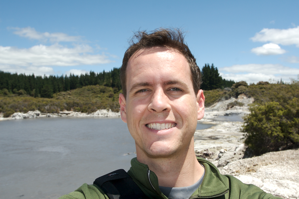
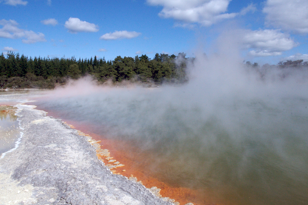
After Hell’s Gate, I headed to Wai-o-tapu Thermal Wonderland. This place is incredible. The thermal pools are gigantic, and most are very colorful. My favorite by far is the Champagne Pool, which is a 65m diameter pool of bright blue water, with a brilliant orange ledge around the rim, just under the waterline. Sadly , it’s rather difficult to photograph, as there’s a tremendous amount of steam rising off the water at any given time, as the surface temperature is about 165 degrees farenheit. Nonetheless, I took a bunch of pictures, although they didn’t turn out as well as I’d like, mostly due to camera operator error (for the curious, I shot at ISO 1600 by accident all day). After leaving, I stopped by some mud pools just outside the park, having fun just staring at a giant boiling mud puddle, trying to guess when the next large air bubble would rise and cause mud to gush into the air.
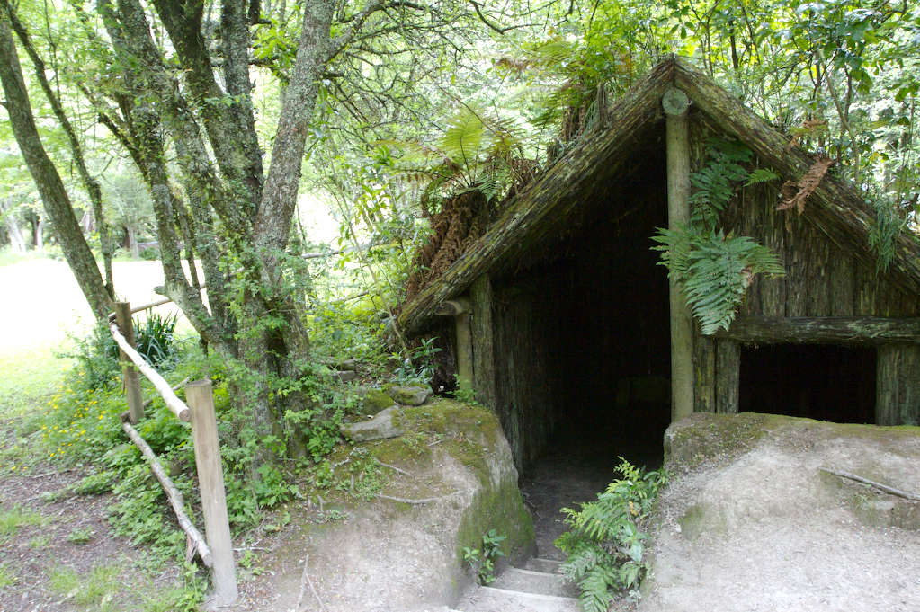
The next day, I headed down to the Buried Village of Te Wairoa, which was a Maori and colonial village buried in a volcanic eruption in 1886. The guided tour was excellent, and conducted by the descendant of a famous Maori guide who lived in the village at the time of the eruption. Here I got to see the construction of Maori dwellings up close, including the usage of the tree fern trunks for walls and roofs, and the inclusion of secret escape doors (in case of attack from other Maori). Around the back of the excavated village was a trout stream, where the guide said there were “very large” trout, holding his arms out to show 2 feet or so of length. I thought he was exaggerrating, but if anything, he was understating how enormous the trout in the stream are. Also, there was a short hike past a beautiful waterfall, going down a steep set of steps to its base. The Buried Village was a definite highlight of my trip thus far.
At the village, I decided to check and see when I had to be in Fiordland for my one scheduled activity of the trip, hiking the Milford Track. It turned out that I had booked it for the 29th of November, which meant that I had only 7 days to get to the other end of New Zealand. Realizing this, I jumped in my van and started driving. First heading up to Rotorua to fill up with diesel, I then headed south. I considered stopping in Taupo, a major tourist town on the edge of a beautiful lake, but instead kept driving all the way to Napier.
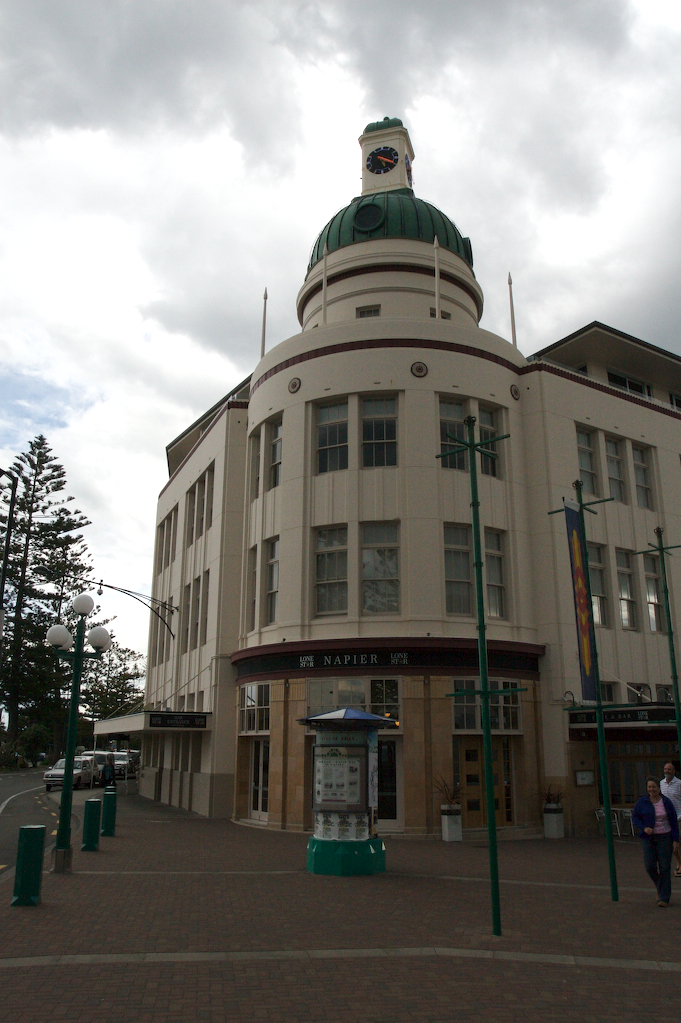
Napier is a small city (50,000 people) on the Eastern seabord of New Zealand. Much of Napier was destroyed in 1931 by an earthquake (followed by a fire), and so much of the downtown area was rebuilt around that time in an Art Deco style. I spent some time walking around the city center (or centre, as they spell it in NZ) enjoying the cool looking buildings, many of which wouldn’t look out of place in California. Then, I had a seafood dinner at a cafe fronting the bay, and headed to another carpark. This carpark had a pleasant surprise in store for me: the fastest wireless Internet access I found in New Zealand. It was great. I even got to video chat over iChat with some of my friends back home, all while sitting in the back of my campervan. I also took this opportunity to upload a bunch of the photos I’d taken.
Thanksgiving
The next day, Thanksgiving, I booked passage on the Interislander Ferry from Wellington to Picton for the next morning and started driving to Wellington. The drive took me through some very beautiful country; country populated, mainly, by sheep. There were also a few vineyards and field crops thrown in for good measure, but still… Sheep. Lots of them. The other memorable part of this drive was the extreme wind. This had the unfortunate effect of making my campervan much harder to control than it should have been. At one point, I was considerably worried that my van was going to be toppled by a gust of wind, so I drove very, very slowly.
Fortunately, I made it to Wellington without any wind-related mishaps. As it was Thanksgiving, I decided to try and find something suitable to eat in Wellington proper. The best I could do was a steak dinner with guacamole and chips at a restaurant purporting to be Texan. Sadly, they didn’t know how to make chips, guacamole, or steak particularly well. All the same, I was thankful that I could have a meal at least resembling something American, and thankful that I was on such a great vacation. Being alone on Thanksgiving also made me that much more aware of how thankful I am for all of the people in my life, who I missed very much.
To the South Island
I got up early the next morning in anticipation of my ride on the Interislander. Heading into the ferry terminal an hour ahead of my departure, I noted that it was still windy in Wellington. In fact, as I waited in line behind the other campervans, I noticed them all rocking gently back and forth in the wind.
Once I had parked my car in the ferry, I headed upstairs to watch our departure from the viewing platform. It was a windy but mostly clear day, and I had a decent view of the Bay and of downtown Wellington as the ferry pulled out into the sea.
On the Road to Te Anau
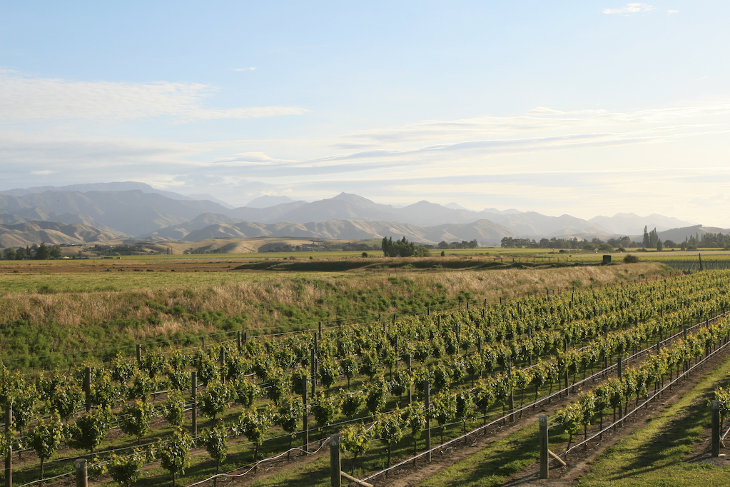
After arriving in Picton, on the South Island, I immediately started to head south. The drive took me along the eastern coast of the South Island, through country that reminded me much of California. There were browning rolling hills that looked like the area around King City, as well as a few row crops and a lot of grape farming to round out the similarities. Of course, rather than cattle dotting the fields and hillsides, there were sheep.
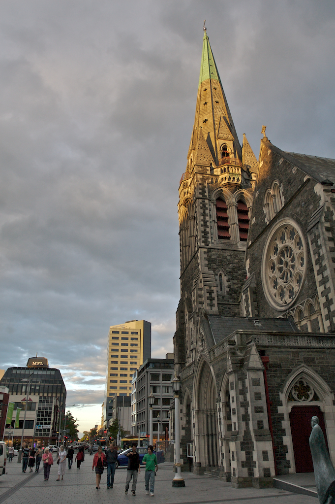
The drive took me down the coast, through areas that reminded me of Big Sur, with a narrow highway winding a path between shrub covered rock on one side and the sea on the other. Around 7pm I finally arrived in Christchurch and checked into a carpark. After that, I wandered around town for a bit, saw that the city center is indeed dominated by a giant church, and got to see a bit of the soapbox rantings the city center is so famous for. After wandering up and down the streets looking for a place to eat, I settled on sushi at a restaurant called Sala Sala. I had a crayfish combo, which consisted of half a crayfish sashimi style (raw), and the other half grilled, with a salad, crayfish miso soup, some assorted snacks, and a small dessert. The crayfish was excellent! By the time I got back to the carpark, however, it was 11:30, and I realized that the extended daylight hours of the low southern hemisphere were really throwing my schedule off. All the same, I appreciated them, as I was able to do and see a lot, every day, all day, with mostly full sunlight until mid-evening.
The next day, rather than doing any more sightseeing in Christchurch, I spent some time booking transport to and from the Milford Track, something I had forgotten to do earlier. Luckily, the Department of Conservation and Real Journeys web sites together enabled me to get booked up easily, and I was back on my way. So, I set out for Dunedin, which is much further down the coast from Christchurch. It was a long, mostly uneventful drive. I will say, however, that this particular drive made me miss the US Interstate Highway System. The speed limit in NZ is about 62mph, and the roads go through every little town along the way, in each of which you have to slow down to 31mph or less. At home, the drive would’ve only taken 3.5 hours, but in NZ it took over 6. The tradeoff, however, is that in NZ there are loads of vibrant and healthy small businesses along the highways, with real communities rather than suburban sprawl, whereas in the US such towns are much less healthy.

Dunedin, it turns out, is an interesting town. It’s built in a bit of a hilly seashore area, and as such there are a lot of hillside houses with nice views of the ocean. There is also a lot of stone architecture in the town center, with the rail station being a prime example. It also seems like the churches all tried to outdo each other in their gothic stone grandeur.
The next day’s driving took me through a whole bunch of quirky small towns, including Gore, which bills itself both as the Brown Trout Fishing Capital of the World and the Country and Western Music Capital of New Zealand.
Gateway to Fiordland
On arriving in Te Anau (the “Gateway to Fiordland”), I got settled in yet another campervan park, and walked into Te Anau proper. The town is fairly small (population 1,900) and is mostly centered around tourism in the Fiordland region. There are tour operators for everything from fishing boats, to seaplanes, luxury tour boats, sightseeing buses, and everything in between, all jockeying for the attention of travelers seeking the spectacular outdoor scenery of the fiords. The town itself offers some impressive scenery, sitting on the edge of Lake Te Anau (the largest lake on the South Island), with snow-capped mountains lining the horizon.
On recommendation of the carpark staff, I headed over to the cinema to watch a 30 minute film about the Fiordlands. The film, Shadowland, was a kind of cinematic tour of the park, with no audio track except some mood setting music. It has a lot of really spectacular shots taken from a helicopter, and really conveys how spectacular the area is. I was so impressed with the scenery and camera work that I decided to purchase the DVD, and ever since have been showing it to whichever of my friends will watch.
The next day, I took a guided tour through the Te Anau glowworm caves. This involved a ferry trip across the lake, where we were led into a small limestone cave and back past waterfalls and a raging underground stream to board a small boat. This boat was pulled via a cable by our guide through a pitch black cavern in which we were able to view the glowworms all over the walls and ceiling. It was like staring at oddly close and vibrant green stars. It was a bit of a surreal experience, and one I’d recommend.
The next couple of days were spent doing some last-minute shopping for camping gear and food supplies, picking up tickets, and arranging for secure storage of my computer and campervan. The Department of Conservation staff were helpful, but also scared me with talk of water up to my hips on sections of the Milford Track, all-pervasive rain, and snow and wind to boot.
The Milford Track
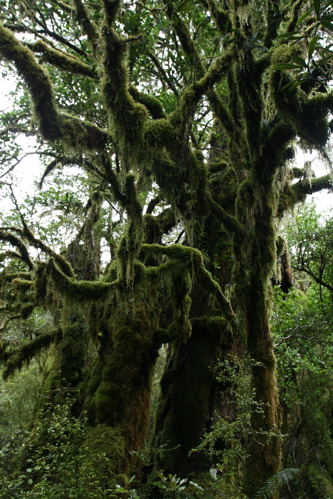
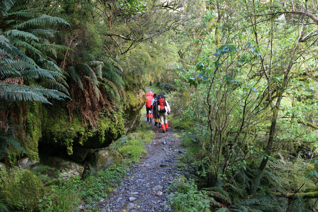
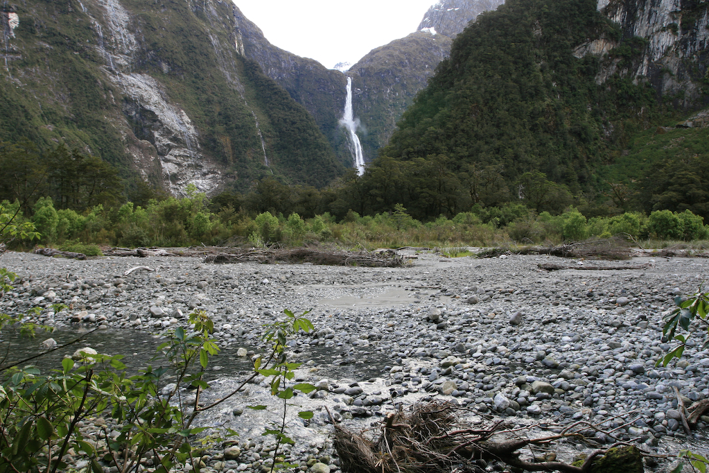
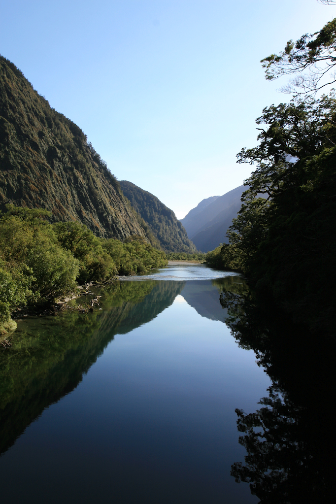
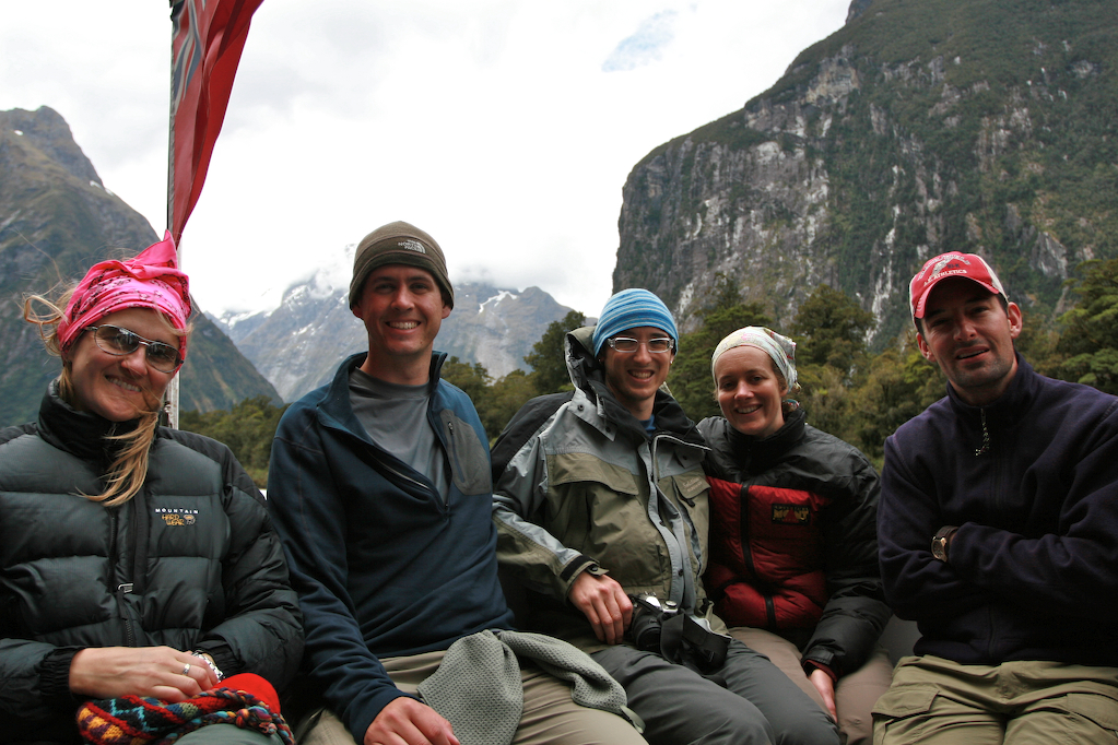
Bus pickup from Te Anau on the 29th was at 9:45am at the Department of Conservation (DoC) center. After a short ride to Te Anau Downs, we took a ferry to Glade Wharf, the start of the track. The walk started in beech forest, with lots of mossy ground cover, and also lots of rain. In fact, it rained continuously all day. I was able to take my camera out for a bit, shielding it with my umbrella, and snap a few photos along the walk. The rain-obstructed views were of forested, snow-topped mountains rising straight up from fast-running streams and rivers, swollen with the day’s rain.
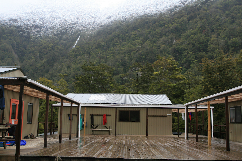
At one point, there was a 4 minute side walk to a “wetland” area; really a bit of a bog. It was interesting, however, as the track led to a small viewing platform in a boggy clearing, which afforded views of the surrounding mountains. Back on the main track, there were standing puddles several inches deep on the track. After a little over an hour we reached Clinton Hut, our first stop. I was surprised to find that Clinton Hut is both larger and more well-appointed than I had imagined. There are two bunk rooms, each with 20 bunks, plus a restroom outdoors (with sinks and flush toilets!), as well as another hut with gas cookers, benches, sinks, and a wood-fired stove. A ranger cabin sits nearby, with a friendly fellow staffing it full time. Out back is a walkway to a helicopter pad which also serves as a good viewing platform for some waterfalls (from which the Hut draws its water) and mountains.
As we arrived early in the afternoon, we built a fire and waited for the complement of our party to arrive. Later that day they started to trickle in, significantly wetter than ourselves. Apparently, the puddles had gotten quite a bit deeper since we’d arrived, and they’d had to walk through water that went past their boot tops. Around 7:30, the ranger dropped in to give a brief speech and collect our hut passes. He had walked up to the next hut and back to check trail conditions, and reported that the water was up to the middle of his thigh! So, I expected to get thoroughly wet the next day.
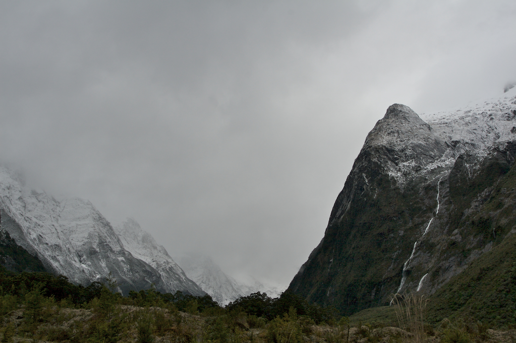
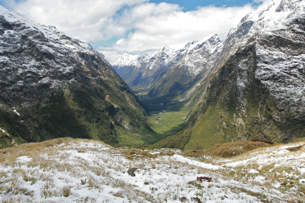
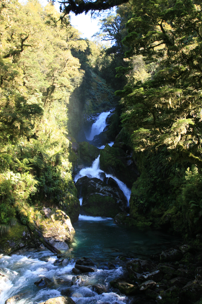
The second day’s walk was a gentle climb through a long valley. Most of the walk was through beech forest, while sections had only grass and low brush. The steep sides of the valley were dusted with snow part way up, giving them a rather striking appearance. These mountains rose straight up out of this narrow valley, and the rain and snow runoff gave rise to thousands of small and large waterfalls cascading off the sides and onto the valley floor. It was amazing, and by far the most awesome part of my trip thus far.
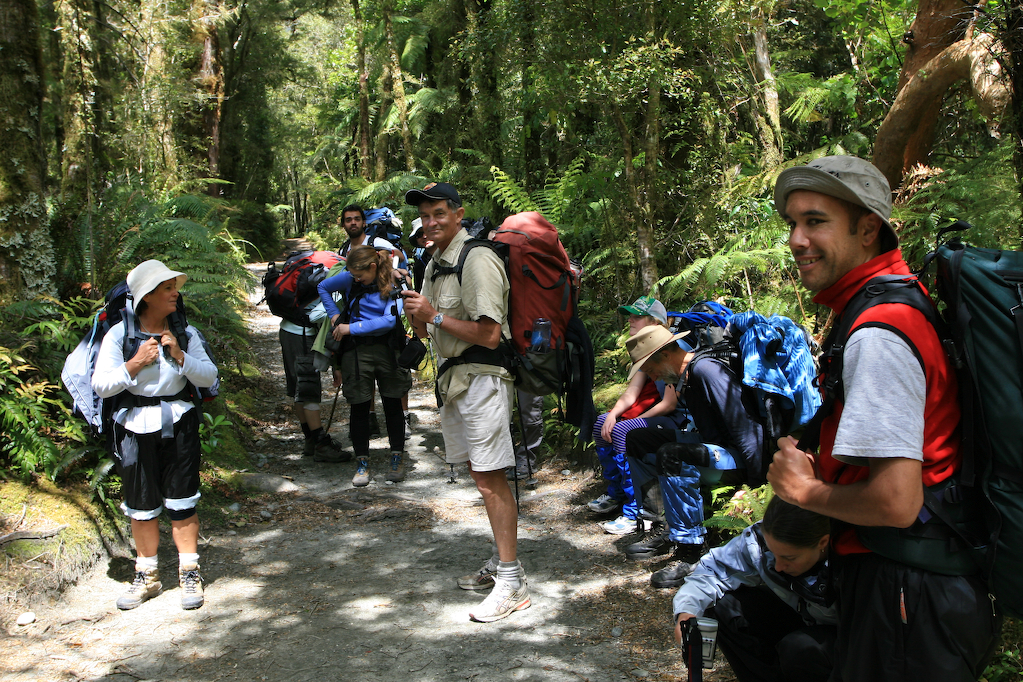
I stopped for lunch at a guided walk shelter. The guided walkers, who pay significantly more than us unguided (or “freedom”) walkers, have luxury lodgings (read showers), with meals prepared for them at stopping points along the walk. Thankfully, they let us use their huts for shelter when we ate lunch, so I was able to take my pack off and eat without getting soaked. Soon after I stopped, a kea showed up at the shelter. The kea is the world’s only alpine parrot. I’d heard about this “clown of the mountains” from my friend JD, but was not expecting them to be as large as this one was! it hopped around as I unpacked my food and ate lunch, peering at me in hopes of an opening in which to rummage through my pack for food and transportable objects. As I ate, other campers arrived, and rather than scaring the bird away, the increased attention only seemed to embolden it. Eventually, I started getting cold, so I packed everything back up and started back on the long walk to the Mintaro Hut. Along the way was a side walk to a small lake. There I was able to snap some shots of Paradise Ducks and of a rather nice waterfall falling directly from the cliffs into the lake on the valley floor.
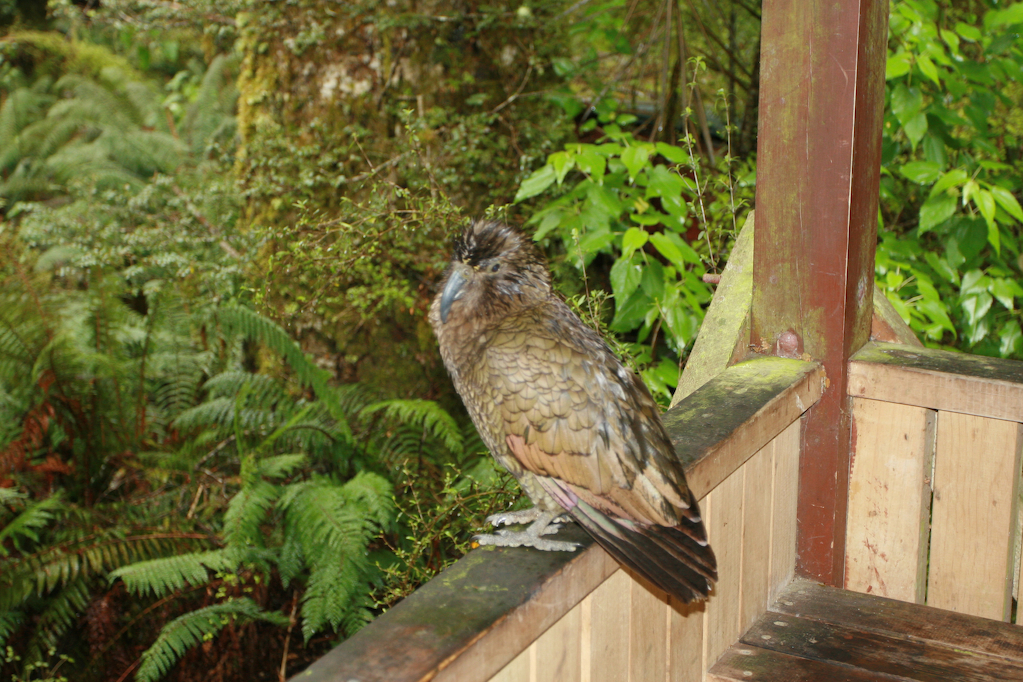
After what seemed like an interminable walk, I finally made it to Mintaro Hut. My hips had been hurting me for the last couple of miles of my walk, and I was glad to finally be able to dump my pack off. Outside the hut was another kea, even more aggresive than the first. It actually hopped up to one of the hikers and started nibbling on his jacket!
All that day, a helicopter had been making passes up and down the valley. During the hut talk that evening, the ranger (a woman in her 20’s) told us she’d been up repairing the trail after it had washed out during the rain. That night, after talking with my fellow trampers (as they call hikers in NZ) for a bit and eating a rather nondescript meal reconstituted from a freeze-dried packet, I went to bed early, feeling tired and sore.
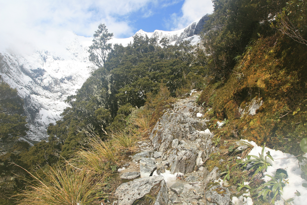
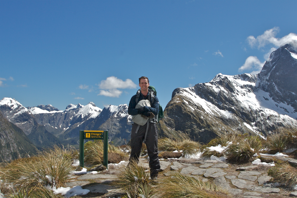
On the third day of my hike, I got up and set about readjusting my pack so it would ride a little higher on my hips. That done, I set out late, having lost a lot of time reorganizing my pack. The initial walk was easy, but I quickly came to the ascent up to MacKinnon Pass. The ascent was difficult, but soon I was rewarded with awesome views back down the Clinton Valley, up which I had walked the previous two days. Eventually, I got to the pass, and saw some of the most incredible views I’d ever seen. At the top, there is a monument to Quinton MacKinnon, who discovered the pass in 1888. Resting at the monument were some guided Japanese tourists, who were having fun photographing the playful keas, and I had one of them take my picture next to the 12 Second Drop. Then, I hiked over to the rest hut, changing into warmer clothes along the way, as it was both very cold and very windy along the top of the pass.
At the shelter, I had lunch with some of my fellow hikers and went out to take a look from the “loo with a view”, a toilet perched at the edge of a cliff looking out over the valley. One of the hikers there said that a guide told her he’d once seen a kea grab someone’s jacket, fly over the edge of the 12 Second Drop, and drop the jacket in the valley. Apparently they also like to steal boots because they offer good protection from the rain.
After lunch, I started down the mountain. The climb down was much harder than the climb up, and took me much longer. The climate also changed quickly from very cold to very warm partway down, so I had to change clothes again. Eventually, I got down to the independent walker shelter, which was next to the hut the guided walkers would stay at that night. I set down my pack and started towards Sutherland Falls which was a short side hike away. I trekked to the falls with my camera and tripod, but wasn’t able to get many shots because the wind was blowing water everywhere around the base and I was immediately soaked in freezing water. On the way back, I tried to find some blue ducks in the river that a guide had directed me to, but was unsuccessful. After retrieving my pack from the shelter, I moved on, stopping further down the river to take some photos of the falls from a distance. A ranger stopped to talk to me, and he told me about some more spots to find blue ducks (I wasn’t able to find them there, either). Later, some people doing the Milford Run ran by, saying “beautiful view” as they passed. The Milford Run is a one day run of the Milford Track. Basically, people who don’t book hut passes can’t camp on the track, so these runners will run the entire track in one day, as a sort of endurance challenge, and presumably to make some sort of point.
Eventually, I got to the hut, just as the ranger’s talk for that night ended. As I ate dinner, I and some others chatted with the ranger, who was a really interesting guy. It turns out that he has ranger friends all over the world, and has a huge collection of park ranger hats and clothes from places he’s visited. After eating, I went to bed as soon as I could, knowing I’d have a long day ahead of me.
On the fourth day on the track, my hiking caught up to me. My feet hurt, badly, but I took some ibuprofin and after a quick breakfast I was on my way again. After passing the Boat House, an avalanche site, and a neat suspension bridge over a still river, I arrived at Bell Rock and Mackay Falls. Bell Rock is essentially a large rock shaped like a bell, having been hollowed out by running water and then flipped upside down. I knelt inside the rock, and took a few shots of the falls, but then had to move on. Later on that day, I stopped and ate lunch near Giant Gate falls with some of my fellow trampers.
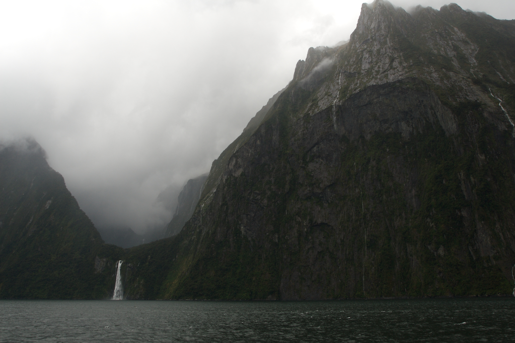
Finally, as my body was about to give out, I reached Sandfly Point, our pickup point for the ferry to Milford Sound. After the brief ferry ride, during which I exchanged contact information with some of my fellow trampers, we reached Milford Sound. While the others went for a cruise around the fiord, myself and a couple of others went to the cafe for some Cokes, beer, and chocolate, three things I’d missed on the track. After that, we caught the TrackNet bus back to Te Anau, where I settled into a hotel room I’d booked, knowing I’d want to sleep in a real bed for a change.
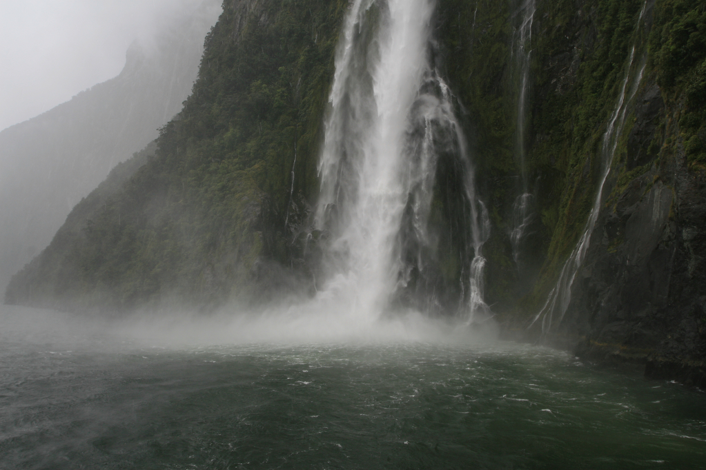
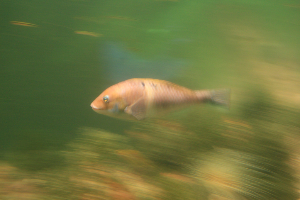
The next day, I drove back to Milford Sound and went on a cruise around the fiord. I also paid to stop off at the Milford Deep Underwater Observatory for a bit. The Deep Underwater Observatory is a viewing platform about 10 meters under the surface of the water. There’s a layer of dark fresh water covering the salt water from the ocean, which allows all sorts of ocean life that is usually only found at deep depths to thrive in the unusually dark water near the surface. My impression was that it was like being surrounded by a giant aquarium (that, or being in one). After getting back from my cruise, I walked along a path to a tidal flat and spent a good 40 minutes just taking photos of the awesome scenery.
Queenstown
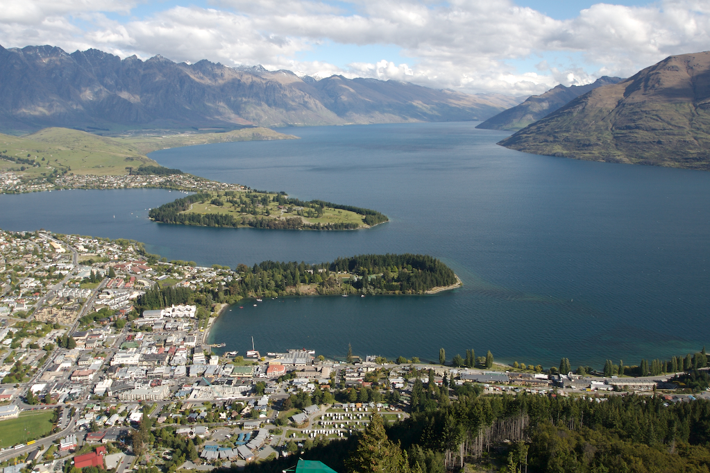
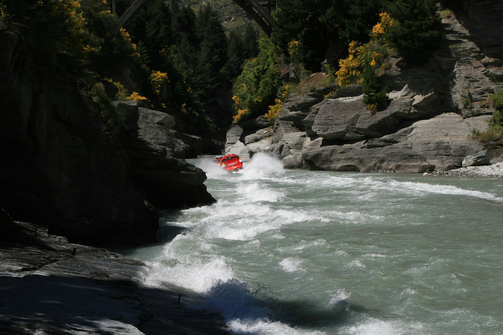
The next day, I drove to Queenstown, world renowned as the extreme sports capital of New Zealand. I wandered around town for a bit, familiarizing myself with the downtown area, and browsing through the hundreds of brochures for touristy activities in the area, deciding what I wanted to do over the next couple of days. My first activity, the next day, was to go on the Shotover Jet Boat. This is a jet boat that zips up and down a narrow river canyon, skirting mere feet past sheer rock walls, and going over sections with just a few inches of water. It was exhilarating, and by the time I got off the boat I was literally shaking from the adrenaline rush.
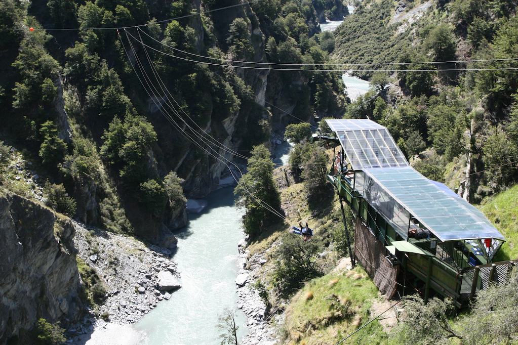
The next day, I went on the jet boat again (half price for the second ride), and in the afternoon I went on the Shotover Canyon Swing. This is billed as “the world’s highest swing”. After being strapped into a chest harness, I jumped off the edge of a platform extended out over a river canyon, free-falling 60m before the swing went taut and I swung through a 200m arc at 93mph. Wow. As people jumped off the edge, white water rafters in the river below would cheer at the people plummeting towards them and swinging over their heads.
Glacier Country
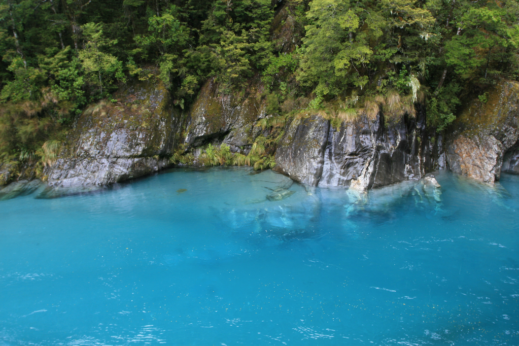
On the 7th of December, I drove from Queenstown to the West Coast. Along the way I stopped at Stuart Landsborough’s Puzzling World in Wanaka, where I wandered around a giant maze for awhile and gawked at an impressive collection of optical illusion rooms and puzzles. Then, I drove over the pass to Haast, stopping at the Blue Pools along the way. The Blue Pools are a bunch of deep pools along a river which are a bright shade of blue, and really quite striking. After a lengthy drive, and a bit of hiking in the hopes of seeing Fiordland penguins on a beach (hopes which went unfulfilled), I got to the town of Frans Joseph around 9:30, which was just after dark.
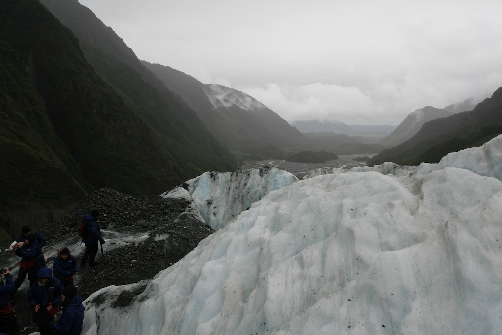
The next day, I went climbing on Frans Joseph glacier for a half day hike. It was a terrific amount of fun! The guiding company I went with took me and probably 10 others up to the glacier, along with our guides. At the base of the glacier, we strapped crampons (spikes) onto our hiking boots, and climbed up the ice stairs the guides carved out with their mining picks. There were probably 5 guides working all day to maintain a very narrow trail of ice steps and bridges up the glacier. We hiked about a kilometer up the glacier, to a point where we stopped and took photos looking back down the valley from which we’d come. I got the distinct impression from the guides that the glacier was extremely dangerous, as they put a lot of effort into making sure the path was clear and the bridges tied down properly. The glacier moves quite a bit in a day, and the paths the guides carve out have to change on a daily basis due to the shifting and melting ice. I took a lot of photos, got extremely wet (it rained), and couldn’t wait to get warm again. All the same, it was an amazing experience.
Up the West Coast
The West Coast of New Zealand is a thin strip of very wet country between the Tasman Sea and the Southern Alps. The drive up this coast reminded me much of Monterey, California, with tall gangly trees, fog, and dense forest along with the requisite rugged shoreline. In the east rise the Southern Alps, snow capped peaks rising out of lush forest. It’s a spectacular drive, and one in which towns on the map are as likely to have 2 people as 200, there being only 30,000 people living on the several hundred mile stretch of the West Coast.
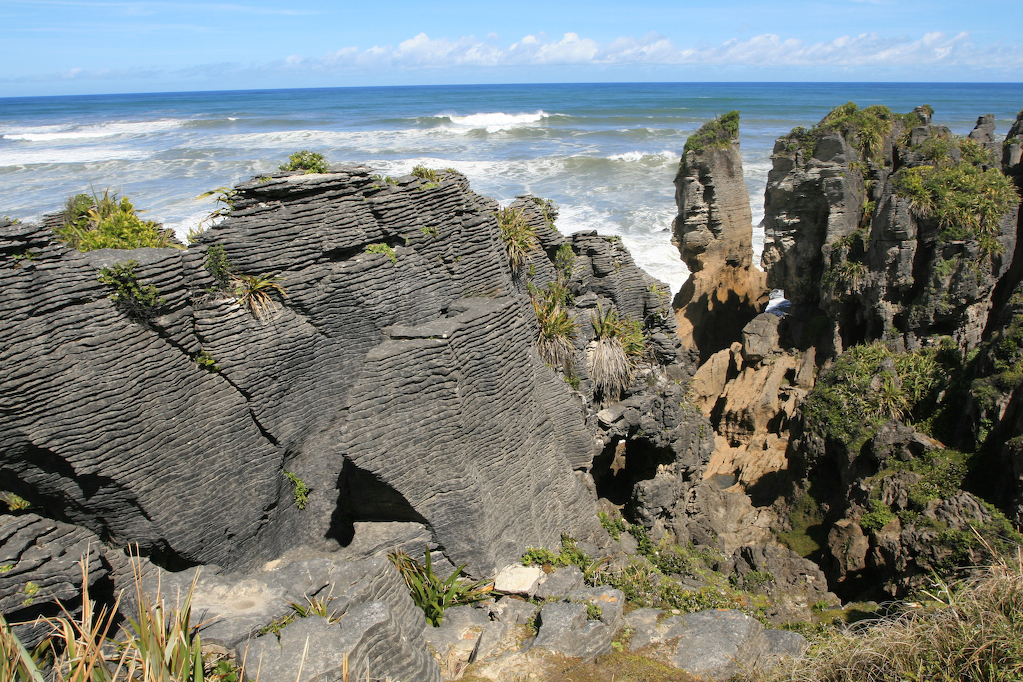
Along my drive up the coast, I stopped at Hokitika to buy some jade carvings. Jade (known as greenstone in NZ) was a treasured good among the Maori for its toughness and beauty, and NZ carvers do a healthy business carving traditional jade necklaces, statues, and other items, with Hokitika being the center of that activity. I also stopped by the Pancake Rocks and Blowholes at Punakaiki. These are rock formations of layered sandstone which look roughly like stacks of giant pancakes. When the tide is up, blowholes in the rocks send sea spraying up into the air in giant jets. I didn’t get to see the blowholes in their full glory (the tide was low), but the weather was bright and sunny, which I was told was quite unusual.
Back to the North Island
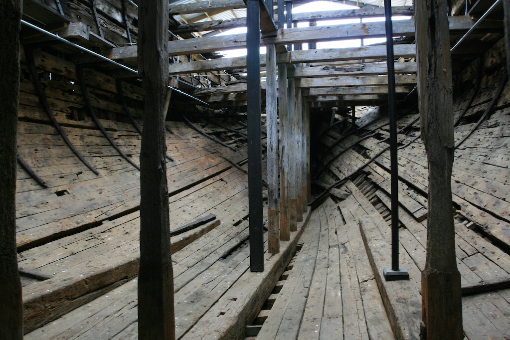
On the way back to Picton to catch the Interislander, I passed through some country which looked a lot like the wine country in Sonoma or Monterey counties. There were golden hills, miles of vineyards, and even California poppies, which triggered a bout of homesickness. Back in Picton, I visited the Edwin Fox museum, where the last East Indiaman is on display. Then, I caught the Interislander to Wellington.
In Wellington, I spent a day just wandering around the city, taking photos and visiting Te Papa, the national museum. Te Papa is fairly large, and has some great exhibits on Maori culture, the cultural history of New Zealand, and New Zealand art. I also took the time to see the latest James Bond Movie, Casino Royale, at the Embassy Theatre. There I got to sit in the leather seats the cast of the Lord of the Rings movies sat in for the premiere, and to watch a movie on the largest screen in the southern hemisphere.
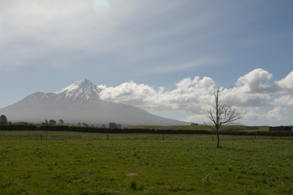
My next stop was New Plymouth, where I did a short day hike up the slope of Mount Egmont. Mount Egmont is a giant volcano which bears a striking resemblance to Mount Fuji, and which affords excellent views of the surrounding countryside. Afterwards, I drove across an extremely hilly area of New Zealand to get to Turangi.
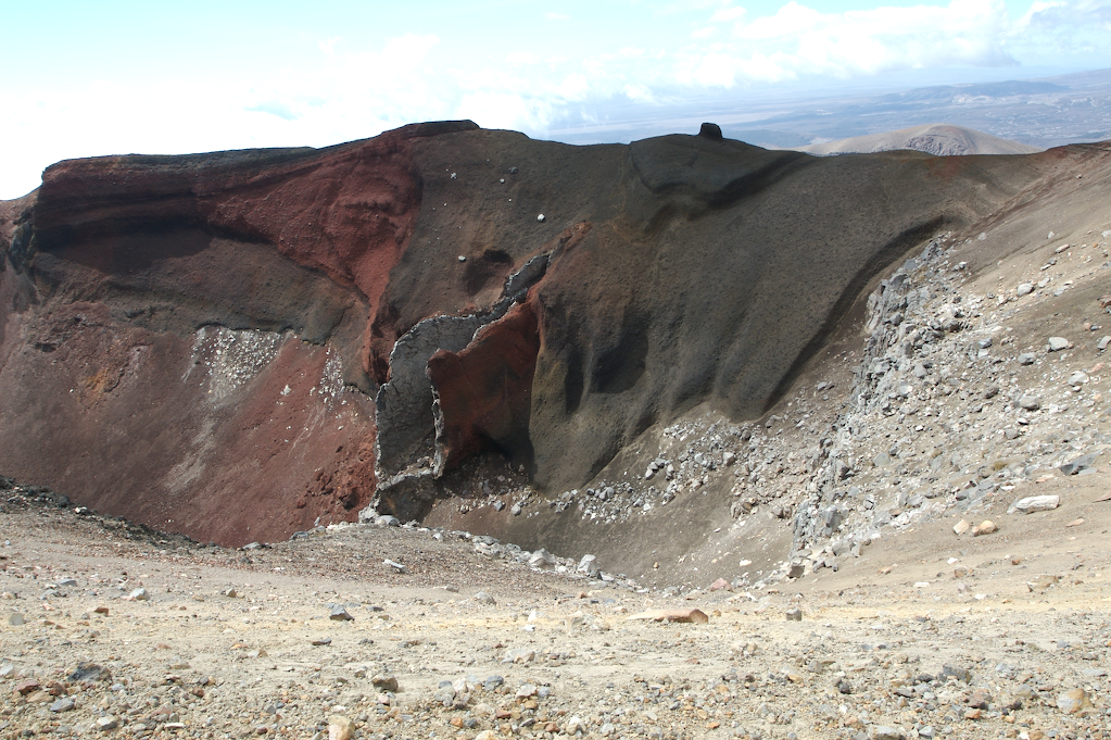
The next day, I got up at 5:30 and took a bus to the Tongariro Crossing. This is a one day hike that takes about 6 hours, and goes up over a high pass of volcanic terrain. It passes several craters, a volcano, and some clear blue lakes. One of the volcanoes it passes is a forbidding looking cone that is familiar to many as “Mount Doom” in the Lord of the Rings movies.
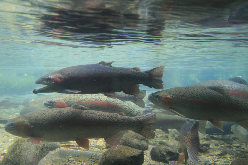
The other major activity in the Turangi area is trout fishing. The rivers in the area are stocked with rainbow trout, and fishing them is a favorite NZ activity. I looked into fishing while I was in the area, but would have needed a guide to find the good fishing spots, and given how much guides cost, it wouldn’t have made sense to go fishing for just one day. I did, however, visit the National Trout Center, which had some great displays on trout fishing, a hatchery, a trout stream/pond, and a nice viewing area where I could look at some large trout through a glass window into a stream.
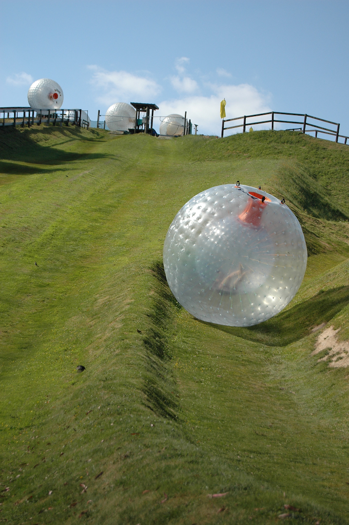
After visiting the Trout Center, I drove north to Rotorua, and after much deliberation I went wet zorbing. Zorbing involves getting in an inflated plastic ball with a bucket’s worth of water, and being pushed down a hill. It was loads of fun, and I ended up going down the hill twice. There’s also a “challenge” where you try to run the length of the hill inside the zorb, and I noticed that my Kung Fu teacher from Pomona was one of the few people to complete the challenge. What a small world!
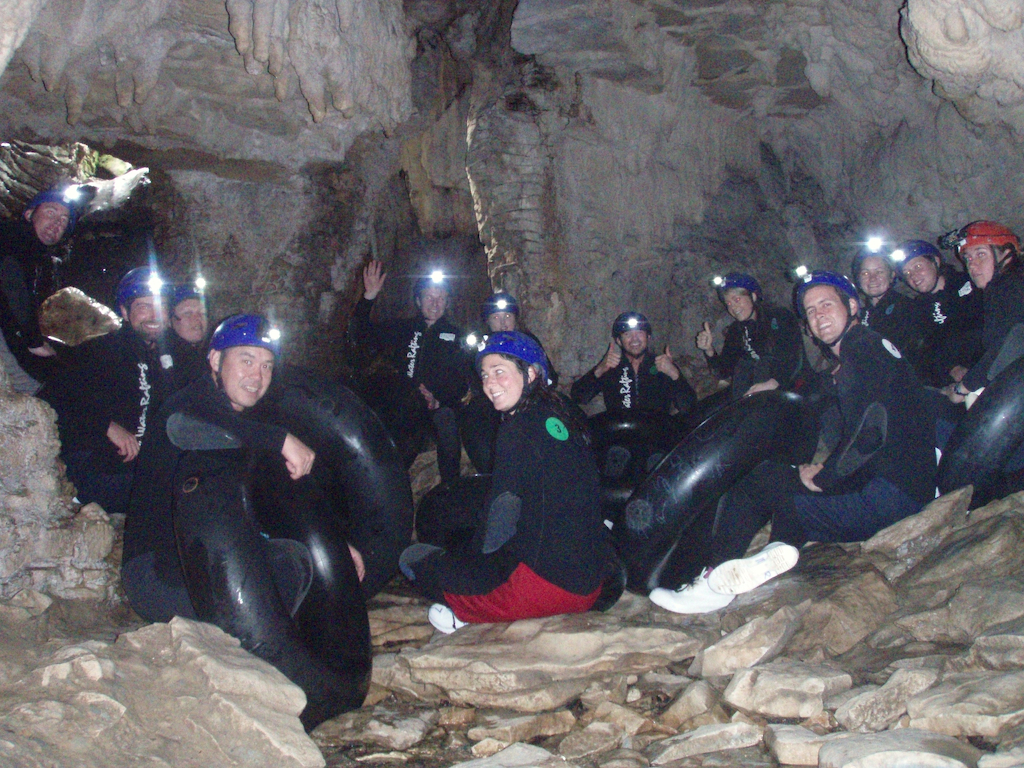
On the 17th, I went “black water rafting” in the Waitomo glow worm caves. We were fitted out with wetsuits, wet boots, and hard hats with lights. Then, we hopped in a van for a drive to the caves and picked out inflated inner tubes for floating through the cave system, which is filled with water. The caves were a bit claustrophobic at first, but I quickly got over that and got into the experience of jumping off waterfalls, clambering around low caverns, and floating on my tube through pitch dark sections chock full of glow worms. I saw a whole lot more glow worms on this trip than I did in Te Anau, and overall it was one of my favorite activities in New Zealand.
Bay of Islands
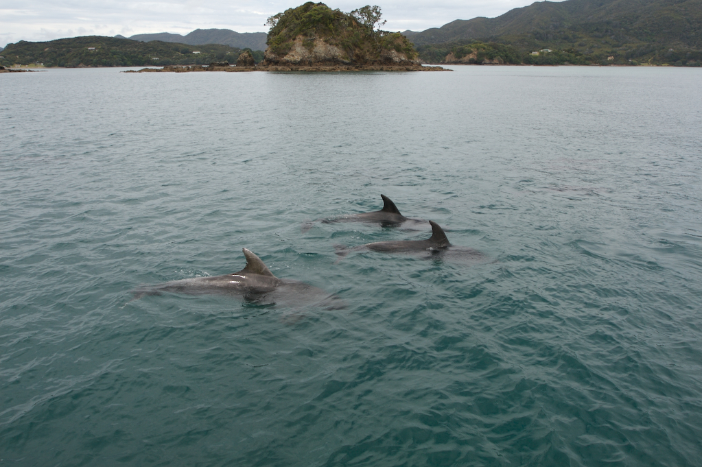
After the caving trek, I drove north to the Bay of Islands, which is on the northern end of the North Island. There, I went on a 4 hour cruise, hoping to be able to swim with the dolphins which inhabit the Bay. The group of dolphins we found, however, had their young with them, so we weren’t able to swim with them for safety reasons (presumably both for the dolphins and the people). All the same, it was fun watching them, whistling at them, and hearing them whistle back. I even saw one leap about 20 feet straight up out of the water, as well as others doing some other acrobatic maneuvers. They were much larger than I anticipated, and really just all-around interesting animals. Later, while wandering around Paihia, I saw some California quail, the same kind we have on the ranch back home. Apparently they were the only upland game bird that did very well in New Zealand’s climate.
The next day, I drove from the Bay of Islands back down to Auckland by way of the Waipoua Forest. There, I saw the tallest and the biggest trees in New Zealand. These are giant Kauri trees; impressive trunks that rise high up through the forest and terminate in tiny (by comparison) tufts of branches.
Back in Auckland
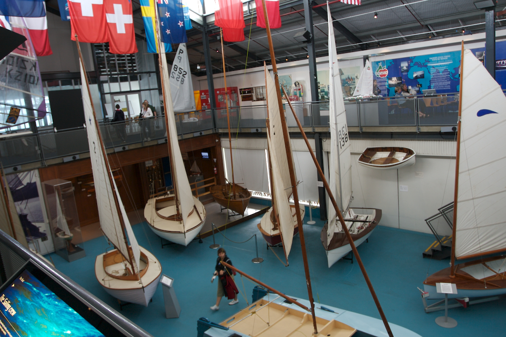
When I got to Auckland, I checked into a carpark site just north of town. In reception, I overheard someone frantically calling around canceling his mobile phone, credit cards, etc, having had his campervan get broken into at the Auckland zoo. I decided not to visit the zoo the next day, and resolved to be very careful parking in Auckland. The next day, I drove into Auckland, parked at a secure carpark, and went shopping for Christmas presents. Afterwards, I went to the maritime museum, which has an impressive collection of boats, South Pacific Islander craft, and related items. Auckland is known as the City of Sails for the large number of boats in its harbors and rich maritime history, and the museum really conveyed how much people there love the sea.
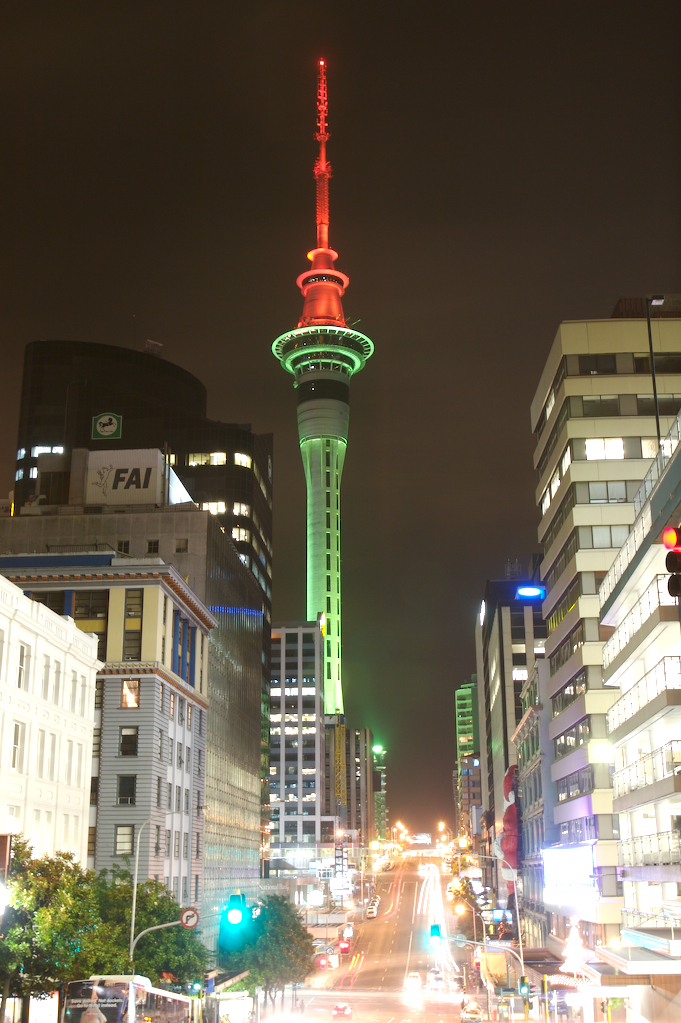
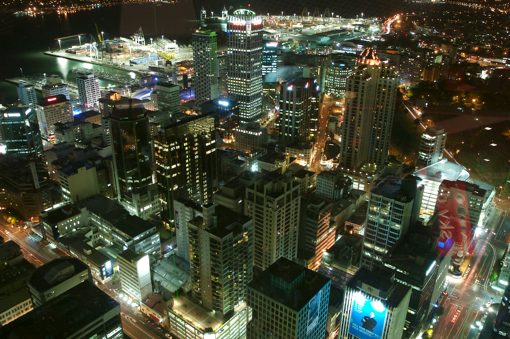
That night, I took an elevator up Sky Tower to get a view of the Auckland nightscape from up high. The top of Sky Tower has viewing platforms where you can lean against very sturdy glass walls and look down at the city from 220m up. It’s a very impressive view.
The next day, I got up and packed, cleaning out the van and throwing out two trash bags full of stuff in the process. Then, I drove over to the rental place and dropped off my car. They were nice enough to watch my bags while I walked up to the Parnell, ate some fish and chips and did some last-minute Christmas shopping. Then, I caught a cab from the rental place to the airport, where I did some last-minute postcard writing and caught my long, long flight back to the US, bidding New Zealand a fond farewell as I watched the country drop away into the sunset from my window seat.
Also…
Check out some photos from my trip: New Zealand Photoset on Flickr.
February 9th, 2007 at 5:52 AM
awsome job,
mouth watering account.
February 11th, 2007 at 1:09 PM
That was great! I need to take some vacation.
February 12th, 2007 at 11:22 PM
Awesome trip and pics man! Sounds like you had a great time.
March 13th, 2007 at 12:06 AM
[…] by Andrew Wooster « New Zealand Trip 2006 […]
May 31st, 2007 at 1:08 PM
Thanks for you taking time and sharing your experience with the public. I love traveling and New Zealand is on my travel list.
July 17th, 2007 at 4:54 AM
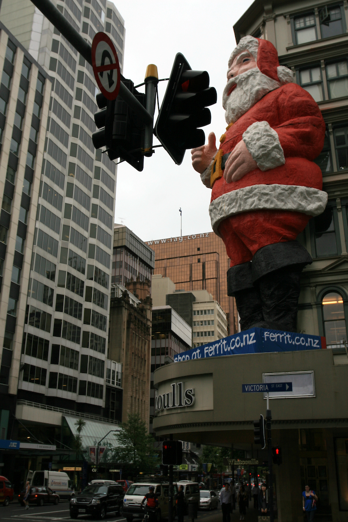
hey andrew, it’s leigh here – i met you at gyozapalooza just recently! i just realised that you and i were in auckland at EXACTLY the same time last year. spooky huh?! i was there on the 15/16th for a film conference, and i took almost exactly the same picture of the giant santa (note: the only exciting decoration in auckland at the time. did not the rest of the city just remind you of the 1970s?!) anyway it was nice to meet you and thanks also for giving me (and dan) a lift back to our hotel after gyozapalooza! hope all is well otherwise. x
February 2nd, 2008 at 3:36 AM
I am off on a 2 month trip to NZ north – stewart island. I have really enjoued your account of the country, I am really looking forward to it now. I hope the weather is kind, but as I am english it probably wont be too much more rain than I am used too.
October 20th, 2008 at 7:38 AM
Awesome job!!!
Really interesting..
June 10th, 2009 at 7:14 PM
You look happy, pics are btop, and you’ve got an inspiring way with words, or is that the trip?
August 18th, 2009 at 6:13 PM
You certainly captured the essence of New Zealand with those fantastic photos.